LEADING PROVIDER OF AMUSEMENT, VENDING & GAMING SOLUTIONS HIGH-QUALITY PRODUCTS BACKED BY EXPERT SUPPORT NATIONWIDE NETWORK OF OFFICES AND TECHNICIANS FAST, RELIABLE DISTRIBUTION AND DELIVERY

Home / Garmin Trolling Motors / Garmin GPSMAP 8610 10” Chartplotter with US & Canada Navionics+ Maps

Garmin GPSMAP 8610 10” Chartplotter with US & Canada Navionics+ Maps

(0 customer reviews)
$2,999.00
🚚 Free Shipping $500+
🛡️ 90-Day Warranty
⚙️ Tested & Configured
🔄 Trade-In Available

In Stock

Description

Garmin GPSMAP 8610 10-Inch Marine Chartplotter

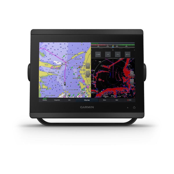
The Garmin GPSMAP 8610 combines powerful marine navigation technology with a sleek 10-inch Full HD IPS touchscreen display built for professional-level performance on the water. Featuring preloaded Garmin Navionics+™ coastal and inland water charts for the U.S. and Canada, this advanced chartplotter delivers superior mapping, networking, and vessel integration for offshore fishing, cruising, sailing, and boating applications.

Designed with edge-to-edge glass styling and premium marine-grade construction, the GPSMAP 8610 offers outstanding sunlight readability and wide viewing angles, even when wearing polarized sunglasses. Its fast internal processor ensures ultra-smooth chart rendering, responsive touchscreen performance, and seamless networking with radar, sonar, autopilot systems, cameras, engine monitoring, and onboard entertainment systems.

With built-in Wi-Fi®, ANT®, and NMEA 2000® compatibility, the GPSMAP 8610 provides complete helm integration and remote connectivity for a fully connected boating experience.

Key Features

  • 10-inch Full HD IPS touchscreen display
  • Preloaded Garmin Navionics+™ charts for the U.S. and Canada
  • SmartMode™ one-touch helm controls
  • Garmin Marine Network compatibility
  • Built-in Wi-Fi®, ANT®, and Bluetooth® connectivity
  • Supports radar, sonar, autopilot, and cameras
  • OneHelm™ third-party device integration
  • Garmin SailAssist™ sailing features
  • Compatible with the ActiveCaptain® mobile app
  • Fast 10 Hz GPS/GLONASS/Galileo receiver
  • HDMI video input and output
  • Supports Panoptix™ FrontVü sonar
  • Edge-to-edge glass helm design

Premium Full HD IPS Display

The GPSMAP 8610 features a bright 10-inch WUXGA IPS touchscreen display with exceptional clarity and anti-glare performance. Designed for marine environments, the screen remains easy to read in direct sunlight while delivering sharp detail and vibrant color accuracy from wide viewing angles.

Its sleek edge-to-edge glass design enhances the appearance of modern helm stations while maximizing display visibility.

Advanced Marine Networking

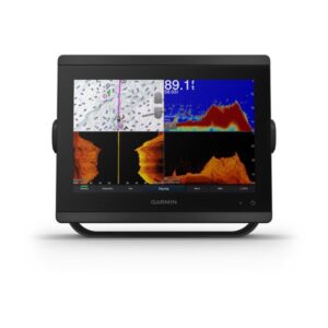
Fully compatible with Garmin Marine Network and NMEA 2000®, the GPSMAP 8610 supports integration with:

  • Garmin radar systems
  • Sonar modules
  • AIS and VHF systems
  • Autopilot systems
  • Engine monitoring
  • Marine cameras
  • FUSION-Link™ audio systems
  • Digital switching systems
  • Multiple chartplotter displays

The OneHelm™ feature allows direct control of compatible third-party marine devices from a single display.

SmartMode™ Helm Controls

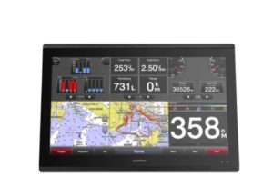
SmartMode™ presets allow quick switching between boating activities, including:

  • Fishing
  • Cruising
  • Docking
  • Anchoring
  • Sailing

With one-touch access, all connected systems and displays instantly adjust to your preferred configuration.

Garmin SailAssist™ Features

The GPSMAP 8610 includes advanced sailing tools designed for racers and cruisers, including:

  • Laylines
  • Wind rose
  • True wind data
  • Tide and current slider
  • Course-over-ground lines
  • Sailing gauges
  • Pre-race guidance

These features provide real-time sailing intelligence for improved navigation and race performance.

ActiveCaptain® App Connectivity

Pair the GPSMAP 8610 with the Garmin ActiveCaptain® app to access:

  • Smart notifications
  • Trip planning
  • Software updates
  • OneChart™ access
  • Garmin Quickdraw™ Community
  • Mobile map management

Technical Specifications

General

  • Display Size: 10-inch Full HD IPS Touchscreen
  • Resolution: 1920 x 1200 pixels
  • Water Rating: IPX6 and IPX7
  • Weight: 5.2 lbs (2.4 kg)
  • Receiver: 10 Hz GPS/GLONASS/Galileo
  • Mounting Options: Bail, flat, or flush mount

Connectivity

  • Garmin Marine Network™ Ports: 2
  • NMEA 2000® Compatible
  • Wi-Fi® Connectivity
  • ANT® Technology
  • HDMI Input and Output
  • NMEA 0183 Input/Output

Navigation & Mapping

  • Preloaded Garmin Navionics+™ U.S. & Canada Charts
  • 5,000 Waypoints
  • 100 Routes
  • 50 Saved Tracks
  • Tide Tables Included

What’s in the Box

  • Garmin GPSMAP 8610
  • Garmin Navionics+™ U.S. & Canada Charts
  • Power Cable
  • NMEA 2000® Drop Cable
  • NMEA 2000 T-Connector
  • Bail Mount with Knobs
  • Flush Mount Kit
  • Sun Cover
  • Trim Piece Snap Covers
  • Documentation

Garmin GPSMAP 8422 22” Marine Chartplotter with Full HD IPS Display

Garmin GPSMAP 8416 16-Inch Marine Chartplotter with Full HD IPS Touchscreen

Garmin GPSMAP 8412xsv 12-Inch Chartplotter Sonar Combo with Full HD IPS Touchscreen

Garmin GPSMAP 8412 12-Inch Marine Chartplotter with Full HD IPS Touchscreen

Garmin GPSMAP 1243xsv Radar Pack for Sale – GN+ Charts & GMR18HD+ Radar

Reviews

There are no reviews yet.

Be the first to review “Garmin GPSMAP 8610 10” Chartplotter with US & Canada Navionics+ Maps”

Your email address will not be published. Required fields are marked *

Get our emails for info on new items, sales and more.

You have been successfully Subscribed! Ops! Something went wrong, please try again.

Need help?
+1-(209) 214-7196

Working Hours

Mon – Fri : 8:30 – 18:00

© 2026 Copyright BETSON